Skip to Content

Geospatial Technology

Geospatial Technology Competency Model

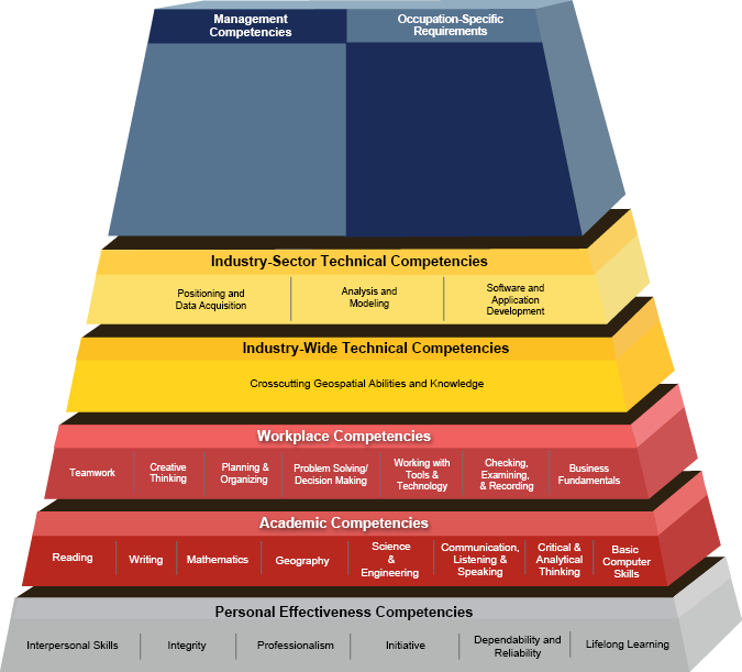
The Geospatial Technology Competency Model framework was developed through a collaborative effort involving the Employment and Training Administration (ETA), the GeoTech Center, and industry experts.

The GeoTech Center surveyed industry professionals, worked with industry subject matter experts, solicited public comments to update the model to reflect the most current knowledge and skills needed by today's geospatial technology professionals. Information about the specific content updates, published in 2023, can be found in the Summary of Changes.

Geotech Center Logo

Scroll down to view the industry model selected. OR Click on the left menu bar to select another model.

Download the industry model and worksheets in several formats  Download the industry model and worksheets in several formats

Geospatial Technology Competency Model


Geospatial Technology Building Blocks Pyramid

<strong>1.1 Interpersonal Skills</strong> Demonstrating the ability to work effectively with others. <strong>1.2 Integrity</strong> Displaying accepted social and work behaviors. <strong>1.3 Professionalism</strong> Demonstrating commitment to the values, standards of conduct, and well-being of one`s profession. <strong>1.4 Initiative</strong> Demonstrating a commitment to effective job performance by taking action on one`s own and following through to get the job done. <strong>1.5 Dependability and Reliability</strong> Displaying responsible behaviors at work. <strong>1.6 Lifelong Learning</strong> Displaying a willingness to learn and apply new knowledge and skills. <strong>2.1 Reading</strong> Understanding written sentences and paragraphs in work-related documents. <strong>2.2 Writing</strong> Using standard English to create work-related documents. <strong>2.3 Mathematics</strong> Using the principles of mathematics to solve problems. <strong>2.4 Geography</strong> Understanding the science of place and space.  Knowing how to ask and discover where things are located on the surface of the earth, why they are located where they are, how places differ from one another, and how people interact with the environment. <strong>2.5 Science and Engineering</strong> Knowing and applying the principles, rules, and methods of science and engineering to solve problems. <strong>2.6 Communication—Listening and Speaking</strong> Giving full attention to what others are saying and speaking in English well enough to be understood by others. <strong>2.7 Critical and Analytical Thinking</strong> Using logic, reasoning, and analysis to address problems. <strong>2.8 Basic Computer Skills</strong> Using a computer and related applications to input and retrieve information. <strong>3.1 Teamwork</strong> Working cooperatively with others to complete projects. <strong>3.2 Creative Thinking</strong> Recognizing, exploring, and using a broad range of ideas and practices. <strong>3.3 Planning and Organizing</strong> Planning and prioritizing work to manage time effectively and accomplish assigned tasks. <strong>3.4 Problem Solving and Decision Making</strong> Applying critical-thinking skills to solve problems by generating, evaluating, and implementing solutions. <strong>3.5 Working with Tools and Technology</strong> Selecting, using, and maintaining tools and technology to facilitate work activity. <strong>3.6 Checking, Examining, and Recording</strong> Entering, transcribing, recording, storing, or maintaining information in written or electronic/magnetic format. <strong>3.7 Business Fundamentals</strong> Knowledge of basic business principles, trends, and economics. <strong>4.1 Crosscutting Geospatial Abilities and Knowledge</strong> <strong>5.1 Positioning and Data Acquisition</strong> Understanding and working with the unique geometric and thematic properties of geospatial data, the factors that affect data quality, and data production technologies, including: data collection, data capture methods, and technologies used to collect georeferenced observations and measurements. <strong>5.2 Analysis and Modeling</strong> Understanding and applying the analytical functions (“exploratory” analyses as well as model-driven analyses) of geospatial software tools. <strong>5.3 Software and Application Development</strong> Design and development of geospatial software and applications, including GIS software products, applications for processing, analyzing, or adding value to remotely sensed data, and applications to automate routine tasks and customize end-user interfaces. Click here to view Geospatial Management competencies Click here to search for O*NET Occupational Competencies Profiles